3 Gaps and contribution
The optimisation of urban energy planning decisions requires extensive computational power. Techniques have been developed to try to overcome this issue. For instance, a Dantzig-Wolfe decomposition is often used in order to keep a computational cost that increases linearly with the number of buildings considered, instead of exponential growth (Figure 3.1). Despite that, at a city scale such as the one of Geneva, the optimisation takes an unreasonable amount of time to compute. This computational limit arises for any model that is trying to solve the energy problem with a good level of complexity and a substantial number of features.
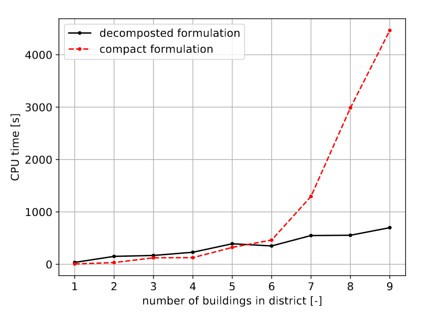
Figure 3.1: Comparison of the computational effort with and without decomposition of the problem.
The second technique is to construct, through clustering methods, buildings archetypes so that the number of buildings modelled is drastically decreased. However, clustering buildings according to their energy demands or their characteristics (thermal envelope) does not allow considering community-wide interactions.
This project aims at filling this gap by providing archetype districts instead of archetype buildings. The objective of this project is to typify the districts of a city. The different districts of a given city are clustered using unsupervised machine learning. The districts within a cluster are then considered as similar so that only one of them is solved, and the results are extended to the rest of the districts of the cluster. The idea is to upscale results obtained with good model precision. This work should bring a coherent framework of what are similar districts. By looking at the characteristic of the clusters, the goal is to create energy-wise archetypes of areas such as the intuitive ones that exist already for land use (urban, sub-urban, industrial, rural, alpine/remote).
This work should also provide a coherent input to the clustering algorithm. Many data are available as of today, but one must be able to recover, analyse and store them so they can be useful. Geographic data refers to two types of data grouped together: spatial data, which are the coordinates and projection information for spatial features, and attribute data, which characterises the spatial data and can be either qualitative or quantitative (Reddy, 2018). For this project, the ambition is to have a flexible project capable of generating all the necessary energetic-linked geographic data on buildings, given the nationally available data in Switzerland. Those data could be visualised on GIS software or used as model input to help decision-making.
As such, the objectives of this work are:
- Provide a functional spatial database of buildings energy data, able to take as an input buildings-related geographical layers and merge them into a valuable output for energy optimisation models and the clustering algorithm,
- Provide a methodology to cluster a city into district archetypes, describing typical districts. Those typical districts should be a reliable way to enable the optimisation of buildings energy systems at a city scale.
The project is divided into two parts:
- Handling the input for the district typification,
- The district’s typification itself.
References
© EPFL-IPESE 2022
Master thesis, Spring 2022
Joseph Loustau